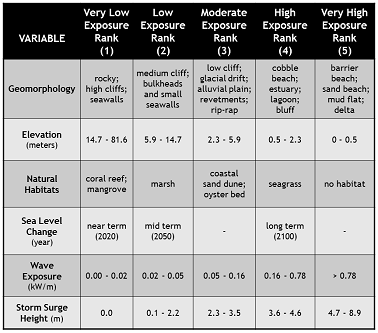
SCIENCE-POLICY SUMMARY County of interest:
  COASTAL EXPOSURE   Scale:


Sea level rise:  


SHOW ME...
current habitats


  DRIVERS OF EXPOSURE  
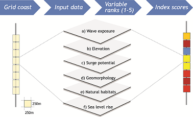
  CLIMATE ADAPTATION STRATEGIES   Map a category:
  1. ENGINEERED
  2. FINANCIAL
  3. LEGAL / REG


 ENGINEERED STRATEGIES
Beach Nourishment
Artificial placing of sand on a beach to replace eroded sand or to protect against future erosion
Cliff Stabilization:
Engineered project to decrease or limit erosion of cliff faces to maintain the cliff in its present location
Dune Restoration Project:
Engineered project to enhance or restore vulnerable or eroded dune systems
Living Shorelines:
Restoration utilizing plants or other natural elements sometimes in combination with harder shoreline structures to decrease wave impacts
Riprap:
Large rocks and boulders placed on shoreline to buffer against erosion and waves
Seawalls:
Structure parallel to shoreline that is engineered to protect against encroaching seas
Elevation of Structures:
Engineered solution where a structure is raised in response to a current or expected flooding hazard
Wetland Restoration:
Restoration effort that allows tidal wetlands to recover in areas that have been diked or otherwise altered from their original conditions


 FINANCIAL STRATEGIES
Buyout Program
Government tool to acquire at-risk properties
Conservation Easements:
Agreements not to develop property in exchange for money or something else of value, such as a tax incentive
Geologic Hazard Abatement Districts (GHADs):
Special district formed to prevent, mitigate, abate or control some geologic hazard
Transfer of Development Rights:
Government program to shift development away from environmentally sensitive areas by exchanging the right to do so in one area for another


 LEG / REG STRATEGIES
Development Moratoria:
Temporary development prohibition while planning proceeds
Overlay Zones:
An additional set of zoning restrictions that overlay the original zoning of a specific area
Redevelopment Restrictions:
Building code amendments to limit the redevelopment allowed in a certain location
Trigger Language:
Planning framework whereby an observed event triggers a shift to implementing specific adaptation policies
  MAP LAYERS

photos

California Coastal Records Project
An aerial photographic survey of the California Coastline
© 2002-2006 Kenneth & Gabrielle Adelman

habitats

Marshes
High Dunes (> 5 meters)
Low Dunes
Seagrass Meadows
Kelp Forests

population

Population Density (# of people per 30 m2)
Low (1 - 5)
Medium (6 - 10)
High (> 10)

zoning

Layer opacity:  %

Agriculture
Parks / Open Spaces / Public Land
Residential
Commercial / Industrial
Special Use and Uncategorized

  NATURE-BASED STRATEGIES FOR ADAPTATION PLANNING Rising sea levels, population growth along coastlines and increasing hazards associated with storms threaten California's coastal communities.

Our team engaged coastal planners, managers, and the public to codevelop a multiscaled decision-support tool that highlights where nature-based and other suitable coastal zone strategies can protect at-risk coastal populations and infrustructure.


FOR SCREEN CAPTURE:
  • Mac users: Hold Shift + ⌘ + 3
  • PC users: Hold Alt + PrtScr, then Ctrl + V in Paint